Ingredients:
- Pick a few points on a map, a variable distance apart, say 20-40km.
- Highlight any good rideable off road trails you know between these points. You’ll need about three fifths of these.
- Highlight any of the unrideable trails you know between these points. Don’t use any more than one fifth of these, or your route will have a slightly sour taste.
- At this stage, you may notice that not all your trails join up. Link as many of these sections as you can with bits of road, yellow ones if you have them, or any that have those small black arrows on.
- You might still have a few loose ends, but don’t worry, these can be linked up using arbitrary rights of way over the top of bleak mountain tops. Again, don’t over do these, as it will affect the bitterness afterwards.
- Once prepared, keep your route in a dark place for a couple of months to mature and don’t tell anyone where it is.
While your route is maturing, you will need to source approximately 70 mountain bike riders (bikepacking variety) who will ride your route. They don’t need to know where it goes at this stage, they just need to think they want to do it. Closer to the date of the event, try to arrange some nice weather. Some threat of rain will add a flavour of excitement and uncertainty. Next you need to expose your matured route to your riders carefully. Ideally, the less time you can expose them to it before they start, the better. Three days should do it. This helps prevent route blindness, hysteria and the onset of panic associated with kit selection or bike set up.
On the day of the event, all riders should come ready equipped. Some will be more equipped than others, and as a result may take longer before they are done. Arrange for the start to be a short distance from registration, and at the top of a steep hill. This should stiffen the muscles slightly before the start, ensuring they will soften or turn to jelly sooner into the ride.
Make the start as unceremonious as possible. A simple “go” at the allotted time should suffice, and your assembled riders should start to disappear into the distance. Some might go off too fast, but they should find this out later and start to slow down.
You can now sit back and relax for many hours. Precisely how many hours before you see the riders again will depend on the proportions of your ingredients.
~
And so it was that the forth Bear Bones 200 was underway. I wasn’t riding for long before I was off and pushing. Geared riders started to come past, but judging by their exertion level, I’m not sure there was much in it effort-wise. The route followed bridleways south from Llanbrynmair towards Esgair Geulan. These were trails I knew from a previous Welsh Ride Thing, and using this knowledge I appeared to be able to keep pace with geared riders simply by staying on the correct route while those around me interpreted their maps differently.
I lead out of Esgair Geulan with Steve Large closely behind. On the run in to Machylleth, the lead group formed comprising of me, Steve, Alan Goldsmith, Phil Richmond, Tom Webb, Chris Purt and Alan Parkinson. Once out of Mach, the route reared up sharply on a tarmac lane. It was not singlespeed territory so I dismounted and watched the others ride off into the distance.
The start had been hard and ridden at a quick pace. Now that I was on my own, I could ride more at my pace. It was a reminder that the race can’t be won in the first 30km, but it can be lost. My pace was more measured for then on.
After Pennal and Cwrt, the route returned to off road and in the distance I could see Steve, Alan and Phil in the distance. I timed the gap to the same point and found I was about 5 minutes down. The route dropped down to Bryncrug before heading over the bwlch to Barmouth. At the top I caught Alan and Phil who had stopped to put jackets on as the rain had started. I opted to chance it and embarked on the descent into Barmouth. Just before the bridge, I caught Steve at a water stop, and while I was doing the same Alan and Phil whizzed past. We were all still quite close.
At Barmouth, Alan and Phil turned into town, and I carried on the route. In the distance I could see Steve and Tom. I stopped to put my jacket on as the rain hadn’t abated, only for it to stop 5 minutes later.
The next section past Sylfaen was really nice, now bathed in the afternoon sun, vegetation glistening with the recent rain, it provided some interesting and varied riding. Remnants of old sheepfolds, ancient stone foot bridges and narrow paths lined with dense high stone walls harp back to the days of the Drovers; history just oozed out of this landscape.
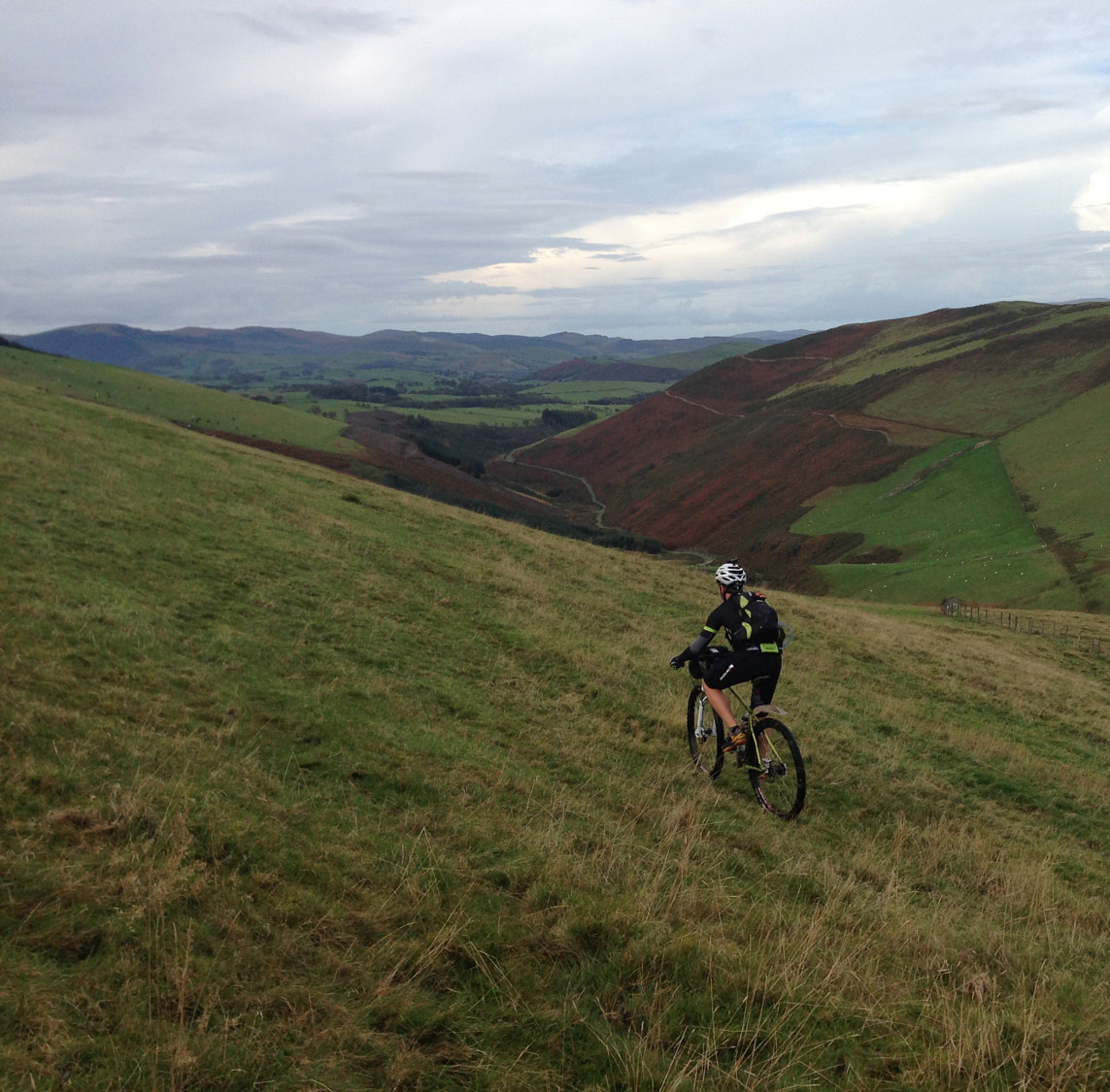
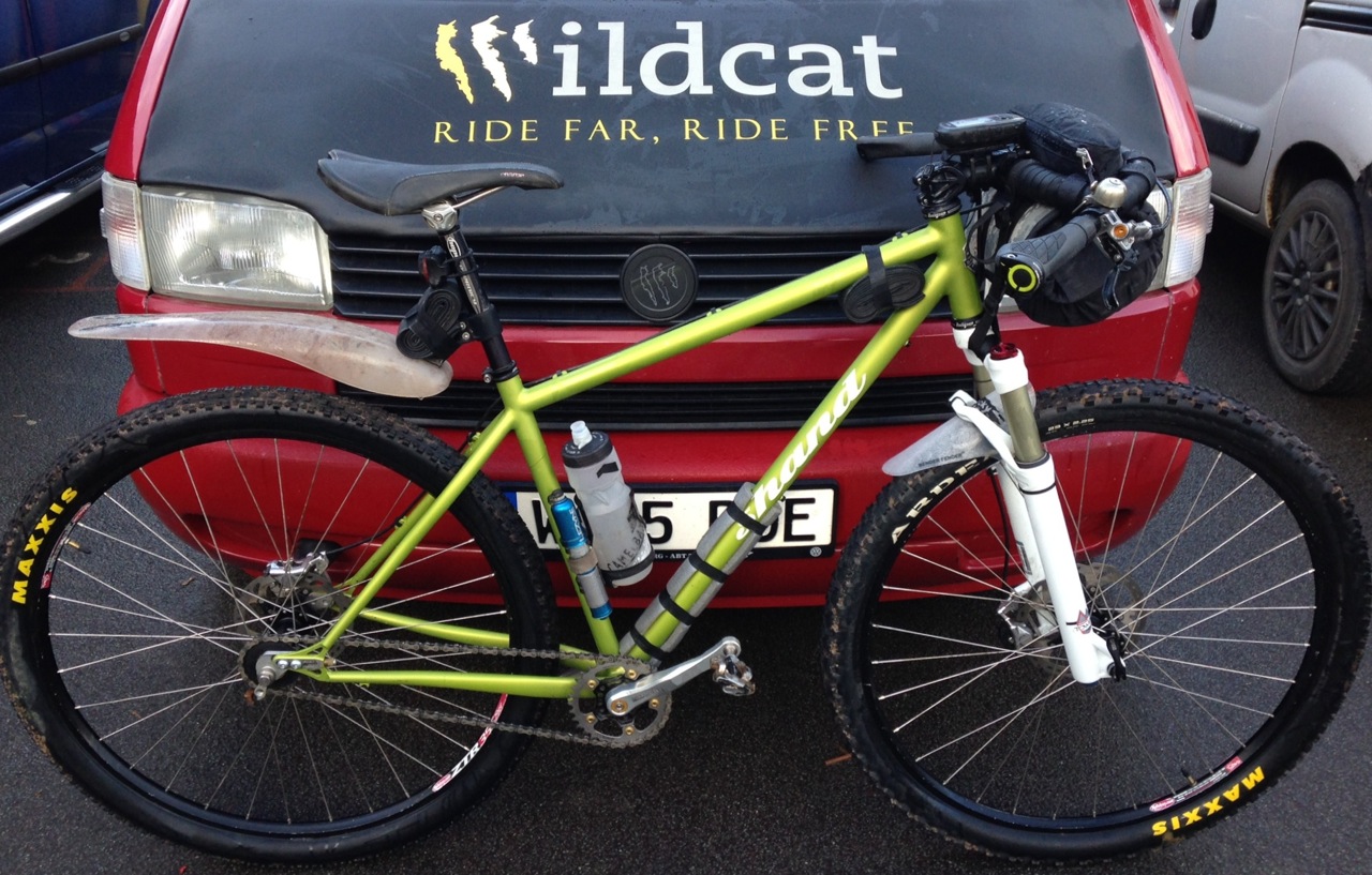
At the first bit of hike-a-bike, I could still see Tom and Steve up ahead. I had prepared my Shand before hand to be as easy to carry as possible. Just a Wildcat Mountain Lion harness at the front for my sleeping bag and bivvy bag, and food and such like in a rucksack. No frame bag and just a single bottle, which I could remove to shoulder the bike. Once I was shouldering the bike, I found I could traverse the ground much quicker than pushing and visibly closed the gap on Tom and Steve, but not quite enough to catch them outright.
The next piece of forest track ended abruptly with a sharp left turn onto a narrow path. Or what was once a path. It was now a stream. It was easier to walk down the stream than attempt to push beside it, so I committed and got through it. What followed was a section of hike-a-bike like none I’ve done before. Vegetation was thick, and though a trail of sorts went through it, it was easy to lose track of it. Shouldering the bike again, I read the landscape in front of me and aimed for the least vegetated bits. The valley bottom was dense tussocks and bracken, but faint ridges ran up to the right that gave way to small rocks and heather. For an hour I carried my bike out of this valley, but by carrying it effectively and comfortably, I didn’t mind. No sense of humour failure was had and once out of the other side I had a strange sense of satisfaction that I had made it through. I’d watched Steve and Tom taking a different route to mine, possibly only 20-30 metres to the west and lower down in the valley bottom, and they seemed to struggle a lot more than I felt I had.
Darkness descended at Trawsfynydd. A short road section lead to a stone track. I stopped at the point where the track continued into the darkness, but the route turned an abrupt left turn across the open hill. A line on the map was the only representation of a path, as laid out before me was more tussocks and bog. I emerged out the other side to see two lights approaching me. It was Steve and Tom. They had followed the track around a longer route and we met where the two lines converged again. We rode together for a while before the climb over to Penmachno forced me off and pushing while I watched them grind off into the darkness.
I caught Steve at the top of road climb where he had stopped to put some extra layers on and rode the chilling descent to Penmachno together. I stopped at the pub for some water and Steve carried on. It was 9:00pm and I’d done about 130km. Steve had said we’ve broken the back of this now, but I was not so sure. There were three distinct hike-a-bike sections still to come.
The first of these came after Ysbyty Ifan. A long and slightly tiresome track lead into the middle of nowhere. A gate in the fence line and a thin line through the grass gave the faintest of signs that this was the right of way. I followed the line of least resistance along beside the fence, climbing constantly. Where the hill plateaued, the trail all but disappeared and I was left searching for sheep paths to follow to ease my passage through this area. I would frequently loose my foot up to the knee in a boggy bit, as it was impossible to judge depth and security of foot placement. Where the trail turned downhill towards Llyn Celyn the track was more defined by still easy to get off line in the dark. In all, it took two and half hours to go from Penmachno to Llyn Celyn; a distance of only 15 km.
At Llyn Celyn the route hugged the shore of the reservoir for a few km round to Arenig. This 25km road section did provide some respite, but the fog had come down and toes and fingers went numb very quickly. I walked a couple of climbs to warm my feet up, only for feeling to come back in the most excruciatingly painful way.
After Parc, the route enters a forest and the second of the three night time hike-a-bikes I was expecting. I’d done this before during a Welsh Ride Thing, encountering wet and marginally unrideable trails. As I emerged out of the other side, I could see the light of another rider some distance behind me. I reckoned about 20 minutes, maybe less.
It was now somewhere around 3:00am and I had my first real feeling of sleepy tiredness. Riding down a track towards the final hike-a-bike section, I missed the turn in my tired state, and had to double back. At this point I met the rider that had been following me; it was Dave Barter. He was surprised to see me.
I thought you’d be done by now?
“You’d think so, wouldn’t you?” I replied. Suffice to say the route to this point was a lot harder than either of us had anticipated.
We pushed up the next section together and into the forest. Once through the gate, I pressed on immediately but soon found I’d lost my companion. No light from Dave behind me through the trees, I wondered why he had stopped.
The descent down to the A494 was familiar territory again, having ridden up this way previously. There was a sense of nearing the end now. Only 30 km to go, and once I’d made it over the top to the A470 summit of Bwlch Oerddrws it was net downhill to the finish. The new light of dawn was emerging in the east now, and by the time I got to Mallwyd, it was fully light. Mindful of my single gear, I was expecting Dave to come bearing down on me at any moment and stealing a place off me in the last few km’s of the route. I kept on the pace as much as I could manage. The climb out of Mallwyd, and the thrutch of the final piece of bridleway was an unwelcome element of the final section, but with much relief I finally joined the road that lead directly to Llanbrynmair. Spinning manically down the road, looking over my shoulder to check for Dave from time to time, I finally entered the village and knew I was safe from being caught.
I rolled into the Community Centre in the village at 8:33am. 22 hours 33 minutes for 223 km. I was third home. Steve Large had been back all of 11 minutes, and Dave came in only 13 minutes after me. Tom Webb earn first place with a 20 hour 40 minutes.
Compared to previous years, the route was substantially harder. Not just a bit harder, but 8 hours harder, compared to my previou best time on the old route.
I’m pleased with the result, but more pleased with some of the smaller details on the ride. My ability to stay awake – something I’ve never found easy, my feeding strategy and the navigation across some really challenging terrain, the bike setup, and particularly the mental strength and composure that I maintained right though have left me quite content. I think Iearnt a lot from the Lakeland 200, and put all that into practice for this event.
Route file here: http://www.strava.com/activities/206604093

3 Comments